Daniel P. Huffman
mastodon 4.7.3An arboreal, poly, gender non-participating mapmaker and cat foster. I like to share my process, write tutorials, and otherwise informally teach cartography (with support from many of you on Patreon).
PSA: PDF readers are not all alike. Here's the same file in Chrome, (Mac) Preview, and Acrobat. Tweakng PDF output settings can help, but only Acrobat will always get it right. I always share drafts with clients in something harder to mess up, like a .jpg or .png. I save PDFs for when we're done.
Rediscovered while excavating my archives. Three vignettes show a bit of how I think about geometric relationships in #map labeling.
(In case the embedded video gets compressed beyond recognition, it's also on YouTube: https://www.youtube.com/watch?v=GQwsRO_1S4Q)
Sometimes when clients ask me to do something, I push back because I don't think it's a good idea. They are paying me not just for my technical skills, but also my experience; it's my duty to them to push back, at times.
But whenever I say, "I don't think this will work," I hear a voice of doubt: maybe I'm just taking a lazy way out; maybe there *is* a way to do what they want that I can't see; maybe another person would figure out how to legibly fit in that extra data layer.
(1/2)
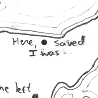
Totally unrelated to current events, here's a little cyanotype map of the Great Lakes that I made back in 2020.
Results have just been posted for the Alliance of Freelance Cartographers 2026 Annual Survey!
https://www.freelancemaps.org/annual-survey/2026
Please share this with freelance mappers in your orbit. This information helps empower our community.
Earlier this year I got to play around with some Roman roads data for Scientific American. The article (with four of my #maps) is out now: https://www.scientificamerican.com/article/new-high-resolution-map-transforms-what-we-know-about-roman-roads-and-the-roman-empire/
Always make sure to generalize your terrain to match your scale.
A couple of dozen Photoshop layers, in a map I just finished. I look forward to sharing it when it's published this summer.
RE: @pinakographos@mapstodon.space
At some point, when energy permits, I hope to do one of my occasional livestreams breaking down the construction of these maps and answering questions.
Increasingly thinking that my decision to stop subscribing to the NYT was a good one.
As I look at the golfball-sized hail on the ground, and the whole sky glows orange, let me say: thunderstorms are just the best.
Just found this super-useful tool: https://cmyk.printingbanana.com/
I work in CMYK a lot. And sometimes I sample an RGB color from an image as a starting point, and want to find a reasonable CMYK equivalent that *doesn't* use all 4 inks. This tool suggests reduced-ink alternatives.
Like many, I suffer from winter depression. However, unlike everyone I've talked to, I also suffer a bit of springtime seasonal affective disorder. For some reason the arrival of the birds and greenery and flowers can make me feel sad, for at least the first few days.
I recently learned that some websites and applications will "italicize" emojis. I will not show you an example because this is a family-friendly account.
I just want everyone to know: whenever my foster cats start to tussle with each other, I start humming the fight music from "Amok Time."
For years I've been a fan of the Athenian democratic idea of randomly selecting leaders. I'm glad to see it getting more attention, and also to see that it's been implemented a couple of times in the modern day. https://www.youtube.com/watch?v=LzbJacGGt1o
The Ancient Invention That Solves Corruption
The Alliance of Freelance Cartographers needs your help! By taking our short annual survey, you strengthen your #cartography community. This survey is for anyone (globally) who did any amount of freelance mapping last year (even a little). https://forms.gle/Em7sULniXUMv87YU7
Please help spread this widely!
A discussion about the wealth of parts of Madison led me to doodle this rough map of 2024 Census data. 1 dot ≈ 20 ppl. Usually you see a choropleth to show income, but I wanted to see how a dot map looked (enabled by the fact that the Census tells you how many people are in each income bracket).
Was feeling randomly down after a day of having my social battery drained. But an evening of listening to my favorite obscure Norwegian synthpop group has perked me up some.
In times past, many of us called Adobe #Illustrator "AI" for short. Now that's untenable. Are there good alternative abbreviations floating around, for when we need to shorten things for social media?
RE: @pinakographos@mapstodon.space
Starting in a few hours (5pm Central). Come by and ask me questions about the life cartographic!
It appears, at least as far as my Etsy store goes, that consumers are cutting back.
Next week I will be answering questions on Reddit in r/Maps. Come on by! https://www.reddit.com/r/Maps/comments/1s5k6ib/upcoming_ama_with_cartographer_daniel_p_huffman/
The Alliance of Freelance Cartographers needs your help! By taking our short annual survey, you strengthen your #cartography community. Please help us spread this widely!
This survey is for:
1. Anyone around the world
2. Who did any amount of freelance mapping last year (even a little). You don't need to "run a business" to take it. As long as you got paid to make a map, and it wasn't part of a regular salaried job, then we want to hear from you!